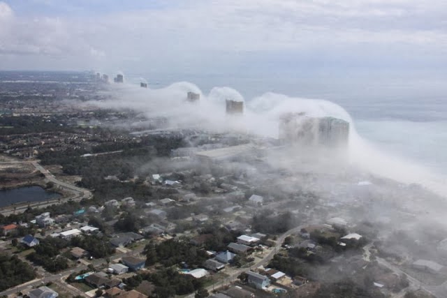
Penampakan Tsunami Awan di Florida

 On Feb 22, 2014  

Pilot helikopter JR hott menangkap gambar-gambar menakjubkan yang menunjukkan awan rendah yang menukik di atas bangunan tinggi yang berdiri di sepanjang pantai Panama City di Florida. Sekilas, tampak seolah-olah tsunami siap untuk menerjang kota.


Meteorologi Dan Satterfield menjelaskan fenomena tersebut:

Cool air offshore was very nearly at the saturation point, with a temperature near 20ºC and a dew point of about 19.5ºC. The air at this temperature can only hold a certain amount of water vapour, and how much it can hold depends heavily on the temperature. If you add more water into the air, a cloud will form, but you can also get a cloud to form by cooling the air. Drop the temperature, and it can no long hold as much water vapour, so some of it will condense out and a cloud will form. In this case, the air was cooled by lifting it about 50 meters over the top of the condos. A parcel of unsaturated air will cool when lifted at a rate of 1ºC per 100 meters. In this case, it probably cooled about 0.5 degrees C, but that was all it took! On the back side of the condos, the air slowly sinks back down and warms at the same rate. As it warms the air can hold more water vapour and the cloud evaporates and disappears!


JR hott, pemilik Panhandle Helikopter, mengatakan bahwa dia melihat efek ini beberapa kali setahun. Yang ini adalah salah satu yang terbaik, karena berkali-kali menghilang sebelum ia sempat menerbangkan helikopter di udara untuk mengabadikannya dari atas.


Sumber: http://versesofuniverse.blogspot.com/2012/02/sunami-awan-di-florida.html
Penampakan Tsunami Awan di Florida 4.5 5 Maher Feb 22, 2014 Pilot helikopter JR hott menangkap gambar-gambar menakjubkan yang menunjukkan awan rendah yang menukik di atas bangunan tinggi yang berdiri di sepanjang pantai Panama City di Florida. Sekilas, tampak seolah-olah tsunami siap untuk menerjang kota. Meteorologi Dan Satterfield menjelaskan fenomena tersebut: Cool air offshore was very nearly at the saturation point, with a temperature near 20ºC and a dew point of about 19.5ºC. The air at this temperature can only hold a certain amount of water vapour, and how much it can hold depends heavily on the temperature. If you add more water into the air, a cloud will form, but you can also get a cloud to form by cooling the air. Drop the temperature, and it can no long hold as much water vapour, so some of it will condense out and a cloud will form. In this case, the air was cooled by lifting it about 50 meters over the top of the condos. A parcel of unsaturated air will cool when lifted at a rate of 1ºC per 100 meters. In this case, it probably cooled about 0.5 degrees C, but that was all it took! On the back side of the condos, the air slowly sinks back down and warms at the same rate. As it warms the air can hold more water vapour and the cloud evaporates and disappears! JR hott, pemilik Panhandle Helikopter, mengatakan bahwa dia melihat efek ini beberapa kali setahun. Yang ini adalah salah satu yang terbaik, karena berkali-kali menghilang sebelum ia sempat menerbangkan helikopter di udara untuk mengabadikannya dari atas. Pilot helikopter JR hott menangkap gambar-gambar menakjubkan yang menunjukkan awan rendah yang menukik di atas bangunan tinggi yang berdir...


1 comment :

  1. ingin wujudkan impian anda , raih kesempatan dan menangkan ratusan juta rupiah hanya di ionqq,silakan invite
    pin bb#58ab14f5

    ReplyDelete